Intext Questions
On Page 1
Question 1. Can you identify and name the various items used in making life comfortable in our villages and towns. List the items and name the material used in their making.
Answer Some items which are used in making life comfortable in villages and towns are as given below.


On Page 2
Question 1. Identify at least two resources from each category.


Question 2. Do you know that India has got the right to mine manganese nodules from the bed of the Indian ocean from that area which lies beyond the exclusive economic zone. Identify some other resources which are international in nature.
Answer: Minerals and oil in the polar regions of the earth are other resources which are international in nature.
On Page 3
Question 1. Prepare a list of stock and reserve, resources that you are familiar with from your local area.
Answer : Stock items include water (from which hydrogen and oxygen ca n be derived as rich sources of energy) is available locally in abundance.
The local river water can be harnessed for generating hydroe lectricity by constructing a dam. This is a reserve resource.
Question 2. Imagine, if the oil supply gets exhausted one day, how would this affect life style?
Answer: Our life style will be affected as given below:
- We will travel to school/office/home by walking, on a bicycle, or by a battery operated vehicle.
- Transportation of materials and goods will be done by bullock-carts, horse-carts or battery operated trucks who se batteries are charged by solar energy.
- All work will slow down to the pace which was common in the 18th and 19th centuries.
Question 3. Plan a survey in your colony/village to investigate people’s attitude towards recycling of the domestic/agricultural wastes. Ask questions about
- What do they think about resources they use?
- What is their opinion about the wastes and its utilisation?
- Collage your results.
Answer: Do it yourself. However, ensure that the people surveyed are living in different areas and of different economic strata ( businessmen, employed persons, domestic servants, etc) so that you get a balanced result.
On Page 4
Question 1. Prepare a list of resources found in your state and also identify the resources that are important but deficit in your state.
Answer: A number of minerals are found in our state. Some of them are Potassium, Calcium, Sodium, Coal, Petroleum, Iron ore etc. But all these are not available in abundant quantity. We have a deficit of coal and bauxite.
Question 2. What resources are being developed in your surroundings by the community/village panchayats/ward le vel communities with the help of community participation?
Answer: Biomass energy, bio-gas, water (by digging well), Solar energy (by setting up solar panels) etc are developed in our surroundings by the community village panchayats/ward level communities with community participation.
Question 3. Can you name some resource rich but economically backward regions and some resource poor but economically developed regions? Give reasons for such a situation.
Answer: Jharkhand state is rich in mineral resources. However, it is economically backward because
- It was originally mostly populated by tribals who were uneducated.
- Due to the rocky terrain, there is very little agricultural land.
- Lack of industrial development in earlier times compared with the rest of India.
The Mumbai region of Maharashtra state is poor in natural resources, but is highly economically developed due to the following reasons
- It is the commercial hub of India with the maximum amount of local, national and international trade transactions taking place in India.
- It has a large number of industries established from a number of years.
- It has a very efficient transportation system for people and materials.
- The people living and working there are well-educated and earning the maximum compared to any other area in India.
On Page 5
Question 1. Try to do a comparison between the two pie charts in figure below given for land use and find out why the net sown area and the land under forests have changed from 1960-61 to 2002- 03 very marginally.
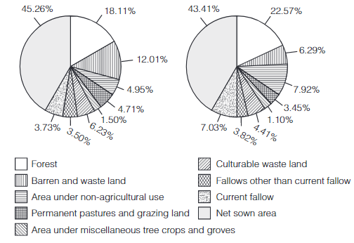
Answer: From 1960-61 to 2002-03, the net sown area has reduced from 45.26% to 43.41% and land under forests has increased from 18 .11% to 22.57%. The reason is that area under non-agricultural use has increased by about 3% from 4.95% in 1960-61 to 7.92% in 2002-03. This consists of buildings roads, etc due to increasing urbanisation. Also current fallow land has increased from 3.75% to 7.03%, causing reduction in net sown area.
On Page 6
Question 1. Find out reasons for the low proportion of net sown area in these states.
Answer: Net sown area in Arunachal Pradesh, Mizoram and Manipur is low mainly due to the hilly and rocky terrain. They are also largely covered by dense forests, which will need to be cut to develop agriculture. Andaman and Nicobar Islands are covered by dense tropical forests and so net sown area is low.
Exercises
Question 1. Multiple choice questions.

Answer:
- (c) Flow is the resource of iron ore.
- (a) Tidal energy can be put under replenishable.
- (b) Deforestation is the main cause of land degradation in Punjab.
- (d) Terrace cultivation is practised in Uttarakhand.
- (b) Black soil is found in Gujarat.
Question 2. Answer the following questions in about 30 words.
- Name three states having black soil and the crop which is mainly grown in it.
- What type of soil is found in the river deltas of the Eastern coast? Give three main features of this type of soil.
- What steps can be taken to control soil erosion in the hilly areas?
- What are the biotic and abiotic resources? Give some examples.
Answer:
- The three states having black soil are Tamil Nadu, Andhra Pradesh and Maharashtra. The crops, which are mainly grown in it, are cotton, Tobacco and Sugarcane.
- Alluvial soil is found in the river deltas of the Eastern coast.
Three main features of this type of soil are –
- It is very fertile.
- It is a transported soil.
- The soil contains adequate proportion of potash, phosphoric acid and lime.
Following steps should be taken to control soil erosion in hilly areas
- Afforestation The best way to conserve soil is to increase the area under forests.
- Terracing and Contour Bunding Terracing and contour bunding across the hill slope is very effective and one of the oldest methods of soil conservation.
- Restricted Grazing of Animals Animals should be moved over different pastures so as to avoid erosion of soil.
- Plugging of gullies to prevent gully erosion.
- Biotic Resources “All resources which are obtained from the biosphere and have life are known as biotic resources”. Thus, forests and their products, crops, animals, birds, marine life, etc are biotic resources.
- Abiotic Resources “All resources which are non-living, are called abiotic resources.” Examples of these are mineral ores, petroleum, etc.
Question 3. Answer the following questions in about 120 words.
- Explain the land-use pattern in India and why has the land under forest not increased much since 1960-61?
- How have technical and economic developments led to more consumption of resources?
Answer : Land resources in India are primarily divided into agricultural land, forest land, land meant for pasture and grazing, land for other non-agricultural use and waste land. Waste land includes rocky, arid, and desert areas. Land is also used for other non-agricultur al purposes such as housing, roads and industry. According to the data for 2002-03, about 54% of the total land area is cultivable or fallow, 22.5% is covered by forests and 3.5% is used for grazing. The r est is waste land, with traces of miscellaneous cultivation. The improper use of forest land has degraded the available land area, and has made conservation of forests difficult. Human activities such as deforestation, mining and quarrying have contributed to the slow growth rate of forests. Thus, land under forest has increased by only about 4% since 1960-61.
1) Technological development has led to industrialisation which has increased the use of natural resources.
2) Technological development has converted subsistence agriculture to commercial agriculture and this has led to the over utilisation of soil.
3) The development of technology contributed to increased production of quality goods and provision of better service s to the people.
4) Technological development has also improved the process of mining.
5) Economic development has led to increasing urbanisation and modernisation which demands more resources.
Project/Activity
Question 1. Solve the puzzle by following your search horizontally and vertically to find the hidden answers.
- Natural endowments in the form of land, water, vegetation and minerlas.
- A type of non-renewable resource.
- Soil with high water retaining capacity.
- Intensively leached soils of the monsoon climate.
- Plantation of trees on a large scale to check soil erosion.
- The Great Plains of India are made up of these soils.
Answer:
